'TRANSFORMING
NATURAL ASSETS
INTO BANKABLE
INTELLIGENCE.'
Environmental Intelligence, Petroleum GIS & Asset Management. Mapping opportunities, supporting licensing success, and creating long-term asset value.
Mapping Opportunities.
Supporting Licensing Success.
Creating Long-Term Asset Value.
Delta Systematics Limited (DSL) provides an integrated spatial advisory platform linking acreage intelligence, digital concession cadastre, competitive bid advisory, and regulatory asset governance into defensible, bankable decision-making.
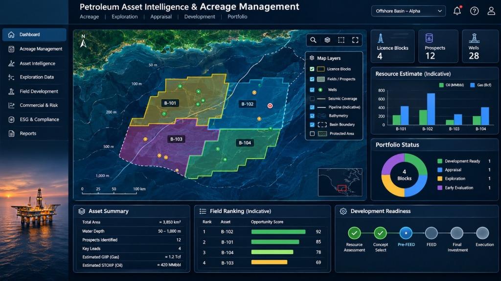
Integrated Advisory Architecture
Four Core Pillars of Petroleum GIS & Asset Governance
Acreage Intelligence & Digital Cadastre
"Trusted spatial foundations for petroleum concession and licence administration."
Core Advisory Services
- Digital concession and petroleum cadastre systems
- Block coordinate and datum validation
- Licence polygons, tenure and ownership mapping
Client Deliverables
- Digital acreage registry and GIS dashboards
- Validated concession boundary maps and datasets
- Satellite monitoring and spatial activity reports
Defensible Spatial Governance Across the Petroleum Lifecycle
From initial reconnaissance and competitive bid packages to field appraisal, pipeline corridor geofencing, and statutory reporting — DSL links technical subsurface data with legally defensible cadastre.
Our Core Expertise
We combine scientific expertise, geospatial intelligence, regulatory alignment, and financial structuring to transform resource-based challenges into sustainable opportunities.
Biological Capital & Natural Asset Development
Positioning ecosystems as measurable and monetisable assets within the bioeconomy and climate finance landscape.
Environmental, Climate Change & ESG Advisory
Comprehensive ESIA, Biodiversity, Climate, and ESG services aligned with international safeguard frameworks.
Petroleum Asset Intelligence & Acreage Management
Mapping opportunities. Supporting licensing success. Creating long-term asset value through spatial cadastre, bid advisory, and asset governance.
Survey, Mapping & Geospatial Intelligence
Comprehensive surveying, remote sensing, and GIS services supporting planning and infrastructure development.
Fisheries & Blue Economy Consulting
End-to-end advisory across the fisheries value chain, supporting investment and community development.
Training, Capacity Building & Technical Advisory
Specialised programmes building technical capacity across environmental and geospatial domains.
Our Products
Geospatial intelligence powered digital tools built to transform how Nigerians access critical services.
GetWell
A geospatial mobile app connecting Nigerians to healthcare facilities with real-time location intelligence, directions, and appointment booking.
3
Major Cities Covered
16+
Health Categories
100+
Facilities Listed
3-in-1
Locate, Navigate & Book


Featured Impact
Over 25 years of proven expertise delivering high-quality geospatial results across diverse sectors in Nigeria and beyond.

Environmental Sensitivity Index (ESI) Mapping
Alakiri Area
Explore the full methodology and results of this project.
Read Case Study
Land Use Mapping and Resource Assessments
Niger Delta Survey
Explore the full methodology and results of this project.
Read Case Study
Bathymetric Analysis
Imo River
Explore the full methodology and results of this project.
Read Case Study
Contingency Plan/Risk Management Operations
SPDC Port Harcourt
Explore the full methodology and results of this project.
Read Case Study
AIRTEL Nigeria Network Mapping
South East Zone
Explore the full methodology and results of this project.
Read Case Study
Environmental Sampling and Air/Water Quality Monitoring
OML 58 (Total E&P)
Explore the full methodology and results of this project.
Read Case Study
Northern Option Gas Pipeline (NOPL) Air Dispersion Modelling
Total E&P Nigeria Limited
Explore the full methodology and results of this project.
Read Case Study
Environmental Evaluation Report (EER) - Enugu Airport
Federal Airport Authority of Nigeria
Explore the full methodology and results of this project.
Read Case Study
Environmental Impact Assessment - Evacuation Road
Mfamosing-Odukpani, Cross River State
Explore the full methodology and results of this project.
Read Case Study
Brass LNG Dredging and Sand Winning EIA
Brass Island
Explore the full methodology and results of this project.
Read Case Study
GIS Project Monitoring and Evaluation
Niger Delta Development Commission
Explore the full methodology and results of this project.
Read Case Study
PHCN Electrical Network Inventory
Ibadan/Ilorin
Explore the full methodology and results of this project.
Read Case StudyA Legacy of Precision
Delta Systematics Ltd. (DSL) is an integrated scientific firm specializing in Environmental Intelligence, Petroleum GIS & Asset Management. With over 25 years of experience, we deliver defensible spatial systems, digital acreage cadastre, and environmental advisory across Nigeria and the wider region.
Our commitment to technical excellence is reflected in our multi-disciplined staff of scientists and engineers. We are dedicated to providing innovative business solutions that create lasting environmental value.
ESRI Business Partner
Certified products reseller for Sub-Saharan Africa
Let's build a
sustainable future
Ready to transform your environmental and geospatial challenges into opportunities? Get in touch with our expert team today.
Port Harcourt (HQ)
0803 736 1230 / 0805 524 6065 / 0803 338 6435
Abuja Office
0806 090 2464 / 0706 919 6287
Direct Inquiry
info@deltasystematics.com
Our Valued Clients
Trusted by leading organizations across the energy and public sectors.


Technology Partners
Collaborating with global leaders in GIS and remote sensing technology.


